
ROGERS PASS, BRITISH COLUMBIA — The afternoon of March 4, 1910, was warm, by winter-in-Canada standards.
Following a nine-day storm cycle, more than six feet of snow had fallen in the Selkirk Mountains, through which the Canadian Pacific Railway had recently been completed. As the route summited Rogers Pass, crude snowsheds protected the most exposed areas.
Rising temperatures caused a series of avalanches to bury the track next to the snowsheds, marooning a passenger train traveling eastward from Vancouver. That afternoon, while the train waited near Revelstoke, at the western terminus of the pass, a crew of railroad workers used a rotary plow and hand tools to clear the slide.

Editor’s Note
Other communities that live and travel in proximity to avalanche terrain have put in place structures that limit avalanche activity, or at least buffer it from the road. Given the perennial nature of the problem on Teton Pass, the News&Guide wanted to explore how those places deal with the inevitable reality of driving through avalanche terrain.
In partnership with the Solutions Journalism Network, which provided the bulk of the funding, we visited Rogers Pass in British Columbia and Snoqualmie Pass in Washington state, talking with avalanche forecasters and engineers to see how their programs balance the often-at-odds needs of backcountry skiers and drivers.
This story, the third in the series, explores how the Canadian government uses snowsheds and other innovative ideas to keep drivers safe on Rogers Pass and if similar infrastructure could be a solution on Teton Pass.
Read the first story about our local mitigation program, “Keeping avalanches off Teton Pass is a Sisyphean task,” and the second one on avalanche bridges on Snoqualmie Pass, “A world without avalanche closures.” Email comments on the series to thallberg@jhnewsandguide.com.
Next week, check out the fourth part of the series, which explores how permit and education systems maintain access to backcountry ski terrain and other public lands in North America, including on Rogers Pass.
Near midnight, they had just finished punching the hole through when a slope across the narrow canyon on Mount Cheops released. The avalanche threw their 90-ton plow off the tracks and enveloped the men, killing 62 of them, including 32 Japanese immigrant workers.
“It’s still one of worst avalanche disasters in Canada’s history,” said Shelley Bird in early March, standing next to a model of the event in the Rogers Pass Discovery Centre. Bird is the public information officer for Canada’s Glacier National Park, which includes Rogers Pass.
To avoid the pass, the railroad churned a five-mile tunnel through the Canadian Rockies. For decades the area sat devoid of industry, quiet as it had been for the uncountable preceding millenia.
When the country began contemplating a true east-west interstate highway in the 1950s, it turned to the railway’s original vision. Crews developed an extensive array of mitigation structures, including five snowsheds in Glacier National Park, huge structures that cover the roadway and allow avalanches to pass overhead.
Snowsheds have long been floated as the answer to avalanche mitigation problems on Teton Pass as well, with the idea being raised as early as 1977. Though Rogers Pass is much different in scale than the thoroughfare that cuts between the Tetons and the Snake River Range, it offers a clear comparison as an important highway through a popular backcountry skiing area.
In looking at Rogers Pass, one thing is clear. Snowsheds are a single tool in a mitigation program that employs innovative technologies and ideas to allow skier access to some of the best big-mountain backcountry ski terrain in the world and accommodate thousands of drivers.
Heading west toward Rogers Pass, the Trans-Canada Highway snakes past logging towns and over the Columbia River before climbing and disappearing into a cleft in the mountains. Almost immediately, the complexity of the terrain is apparent.
A sign welcomes drivers to Glacier National Park; another implores “Avalanche Area: No Stopping.”
Peaks stretch 4,000 to 5,000 feet above the road. Trees fill slopes in the river bottom, slots carved into them by avalanches from overhanging snowfields. Many of the first large slide paths are across the river, away from the road.

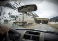
One of five snow sheds near Rogers Pass in Glacier National Park, Canada is shown. The snow sheds, installed between the early 1960s and mid-1970s, help usher about 3,000 vehicles through the pass every day on the Trans Canada Highway, the primary corridor of commerce between Alberta and British Columbia.
After the canyon narrows, putting the road firmly beneath the towering slopes, are Glacier National Park’s five snowsheds, which protect drivers at critical places that span frequent or high-impact slide paths. Unlike on Teton Pass, where any infrastructure improvements would be add-ons, snowsheds were part of the design from the get-go, Bird said, with all five being built in the 1960s and ‘70s.
At their most basic, snowsheds are aboveground tunnels with a pitched roof built over the road. If the avalanche-prone slopes above them slide, the mass of snow travels over the shed and into the river.
However, as shown by a 2019 slide on Colorado’s Red Mountain Pass that buried the road and filled a snowshed, a big slide can still put them out of commission. With what little room they have along Rogers Pass, avalanche program architects used the terrain to help.
“We also have mounds and diversion dams,” Parks Canada avalanche coordinator Jeff Goodrich said. “So, you know, there are deflection dams and catchment basins.”
Goodrich oversees all avalanche mitigation operations on Rogers Pass. Like Wyoming Department of Transportation avalanche forecasters John Fitzgerald and Brenden Cronin, Goodrich’s only prerogative is the traveling public, both on the highway and the railroad, which outside its five-mile tunnel is subject to avalanches.
In the winter, roughly 3,000 cars and 24 to 32 trains travel the pass each day, with an estimated $65 million in goods transported between Alberta and British Columbia daily. Goodrich’s mandate is simple: Make sure traffic can get through.
Given the scope of Rogers Pass, it would be impossible for snowsheds to be the only infrastructure fix.
“You’ve got 134 avalanche paths that could affect the highway here,” Goodrich said.
To cover the road at each of those slopes would basically require a continuous snowshed through the pass, which would be both a logistical nightmare and financially unattainable. Bird, the public information officer, didn’t know how much the five snowsheds cost to construct because they are so old, but a recent round of major maintenance ran about $17 million.
Updated estimates for building snowsheds on Teton Pass are due out this fall, though previous estimates put the cost of construction in the tens of millions of dollars. Even if money somehow became available, building the sheds during the Tetons’ short construction season could require several summers of traffic delays, impacting commuters and other travelers.
On Rogers Pass, showsheds are only part of the complex system that keeps the road open.
In addition to snow sheds, Goodrich uses a variety of tools, including snow nets, remote triggering systems, seismic sensors, explosives and the earthen dams. Because the pieces work in tandem, he wrote in a 2010 paper, “closure time, or a reduction thereof, is difficult to attribute to a single measure.”

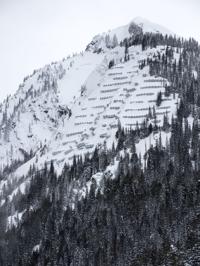
A complex array of snow nets on the south face of Cougar Mountain, just west of Rogers Pass on the Trans Canada Highway. The system holds snow loads in place, keeping it from sliding and thus virtually eliminating the need for routine avalanche mitigation with explosives.
Beside some of the snowsheds, dams extend along the road, sometimes hundreds of feet. They catch snow that might try to squeeze out along the side as the bulk of a slide cascades over the top.
Many paths without sheds have both a dam near the road and a catchment basin directly at the base. They don’t have other infrastructure pieces in place, so the terrain features are the only barrier.
Just west of the pass’ summit, is another infrastructure feature on Cougar Mountain, a steep, probably unskiable slope that overhangs the highway. Rocks pepper the snow, along with a 1.2-mile series of snow nets visible from a mile away, even though they are thousands of feet above the road.
“It was probably the most complex snow net installation project because they were all on ropes,” Goodrich said, also noting helicopters were needed to carry supplies to the site.
Just like on Snoqualmie Pass in Washington state, the nets have been a resounding success, essentially eliminating the slide potential along with the mitigation work. The complexity of building them makes them a somewhat difficult fix, and, as a paper from Canadian engineering firm Alpine Solutions Avalanche Services noted, the nets can be “unsightly,” particularly in an area dependent on tourism.
WYDOT’s Cronin said the same technology could be strung across the expanse of Glory Bowl on Teton Pass. Based on the installations in Washington and Rogers Pass, as well as WYDOT’s snow-supporting structures south of Jackson on Highway 189, nets would probably solve the avalanche problem.
However, Cronin thinks that unsightliness might be an issue.
“I could see this community pushing back against something like that because of the views,” he said.

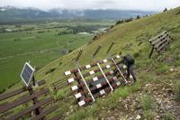
Wyoming Department of Transportation avalanche technician John Fitzgerald evaluates metal snow fences in late June high on the hillside above Highway 89 at mile marker 151 just south of Jackson. Fitzgerald said the array of about 50 fences, installed nine years ago and designed to hold snow in place, have virtually eliminated avalanche problems on the slope and the need for mitigation work.
Those elements — the snow nets, the sheds, the berms — are just the pieces of infrastructure visible to drivers from the road. Hidden in the trees along the roadway are even more advanced pieces of technology, like seismic sensors that detect avalanches or remote triggering systems like the ones used on Teton Pass.
One element of the Rogers Pass system, however, is a little more analog.
Bird, the park’s public information officer, hopped into her Ford Escape at the Discovery Centre. As she’s probably done hundreds of times, she clicked her seatbelt over her waist then flicked on her avalanche transceiver.
“We have to use these when we’re driving to work,” she said. “There’s never been a situation where we’ve had to use them.”
Near the snowshed closest to the visitor center, she turned off the road into a hidden pullout. It was nondescript, except for a 15-foot ring with a small hole in the middle etched into the concrete like a crop circle.
One of about a dozen along the 25-mile pass, the pullout plays an integral role in the Parks Canada avalanche mitigation program. The scale of the peaks makes it impossible to install remote triggering systems on all 134 paths, so for many of them, the federal agency enlists the Canadian military.
Using a pair of howitzer cannons, the military triggers avalanches by firing ordnance into the hills. In a tightly controlled operation befitting the military, the howitzers clear a slope every 4 minutes, leapfrogging each other down the highway and leaving avalanches in their wake.

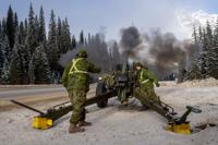
Master Bombardier Ryan Houston from the First Regiment of the Royal Canadian Horse Artillery gives the firing order to Gunner Joshua Caines during avalanche mitigation operations at Rogers Pass, British Columbia in November 2019.
As successful as the berm and catchment system is, slides inevitably still reach the road. A team of plows follows the howitzers to clean up any debris, though the diversion dams and snowsheds diminish the amount of snow and, therefore, time spent clearing the road.
At its core, the Rogers Pass system is founded on the same principles as WYDOT’s mitigation work on Teton Pass: close the road, bomb the slopes, clean up the debris. But Goodrich and his crews have found a way around the thorniest issue of lengthy closures.
“We’ve only had one closure over 24 hours in the last 25 years,” Goodrich said.
Like with the Teton Pass or Snoqualmie Pass avalanche programs, success on Rogers Pass is a strange concept to gauge. The number Goodrich offered as proof of success was an average of about 100 hours of closures over the course of a winter, which seems pretty low, considering the traffic volume, the number of slide paths (134) and the 400 inches of snow the area sees each winter.
Two other measures of success could be the number of skier-triggered slides that affect traffic, a problem that certainly rears its head in the Tetons, and the length of each closure.
The idea of skier-triggered slides hitting the road caught Goodrich off guard. He leaned back in his chair, surprised.
“We’ve never had that occur,” he said.
As for the length of closures, Goodrich and the military teams he works with perform their mitigation work in about four hours. However, because $65 million worth of goods travels the pass daily, drivers, especially those shipping goods, are unlikely to want to sit at the closure gates for half a day.
Instead, Parks Canada divides the pass into four blocks, two of which are rarely closed. Crews bomb and clear the first block in about two hours, then they reopen the pass to allow the pent-up traffic to move, then shut it down again to complete the other blocks.
Drivers only wait two hours at any given time, which makes a difference for shipping time-sensitive industrial parts or food. Even when extreme avalanche conditions necessitate keeping the road closed while all four blocks are cleared, Goodrich’s crews can clear the pass in about six hours.

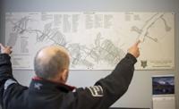
Parks Canada avalanche coordinator Jeff Goodrich describes the scope of Parks Canada’s avalanche mitigation program on Rogers Pass, British Columbia, in early March. “You’ve got 134 avalanche paths that could affect the highway here,” he said.
How can Goodrich manage a much more complex series of slide paths with so much predictability? Experience, for one.
He also has something that would be impossible to replicate on Teton Pass, the weight of Canada’s federal government, which supplies both the money and personnel. Parks Canada is a federal agency, and his crews and the military members who run the howitzers are federal employees. The people who run the snowplows and the forest rangers and law enforcement officers who deal with compliance issues are also federal.
“Because we’re Parks Canada and the land within the park is federal, the avalanche control section and the highway section all basically report to the same director,” Goodrich said. “So basically, we’re all one team.”
On Teton Pass, or really any other mountain pass in the United States, management is fragmented. WYDOT maintains the road, the Bridger-Teton National Forest manages the public land, and Wyoming Highway Patrol or the Teton County Sheriff’s Office catch speeders and scofflaws. Without the seamless control Goodrich has, layers of bureaucracy can inhibit the response or communication with commuters.
All this infrastructure, the bombing and the efficient traffic management, is in some ways separate from skiing on Rogers Pass. Unlike Cronin and Fitzgerald, who have to factor skiers into their management decisions, Goodrich rarely has to think about whether skiers are liable to inadvertently close the road.
That’s because he has a tool the News&Guide will explore in the next story in this series, a permit and closure system that limits access to certain zones depending on avalanche mitigation potential and danger.
An avalanche, believed to be skier-triggered, barreled onto Highway 22 from Twin Slides, entombing a Jeep and forcing the driver to “swim” out…
In the late 1960s, Wyoming’s highway engineers had a novel idea.
Comments are closed.